Jump to a question in this guide
- Why do the title, survey and house answer different questions?
- What does a current title identify?
- Why request the document behind a registered entry?
- How does a survey connect the boundary to visible features?
- What does Calgary compliance confirm, and what is outside it?
- How do permits and an inspection fit beside the survey?
- Which discrepancies change the next decision?
- How should the buyer coordinate the review?
- What does a fictional driveway and deck enquiry look like?
- What records should remain after the transaction?
- Match the actual parcel and included spaces before interpreting records.
- Read the instruments and reconcile current physical features with qualified advice.
- Keep location compliance, permit history, legal rights and condition findings distinct.
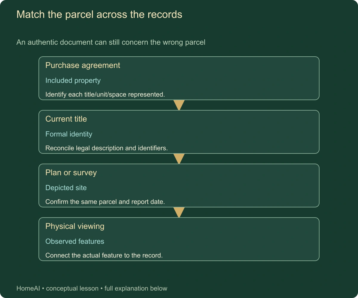
The chain matches the intended property to registered identity, its depicted site and observed features. A shared street address alone is not the complete reconciliation.
About this illustration
No ownership, boundary or included-space finding for an actual property. This is a conceptual teaching model, not an assessment of your home.
6 picture lessons appear beside the questions in this guide. Use them to understand the explanation, then consider what it means for your home.
Why do the title, survey and house answer different questions?
A title identifies registered ownership and interests in land. A survey relates legal boundaries to measured features. A property inspection considers the building and site within its agreed scope. These records can concern the same address while answering different questions. The useful task is to connect them without asking one document to prove something it never examined.
Imagine a fence beside a driveway, a deck behind the house and a narrow route to a rear garage. The fence is an occupied feature. The parcel boundary is a legal boundary. The driveway may serve more than one property under an arrangement that needs legal review. The deck has a location, a physical condition and a permit-history question. Each relationship needs its own evidence.
This guide follows a Canadian purchase enquiry using Alberta title records and Calgary compliance as explicit regional examples. It does not decide any actual boundary, encroachment, access right or contract requirement. Other provinces use their own registry, survey products and municipal processes. Give your legal professional the actual location and agreement instead of importing an Alberta document name into another jurisdiction.
Start with the property you intend to buy: address, legal description, registered parcel or unit, and any parking, storage or access area represented as included. Copy these from actual documents and ask the legal professional to reconcile differences. A marketing photograph of a yard cannot establish that every photographed space belongs to the parcel being transferred.
Distinguish an included space from a space someone has been allowed to use. Parking beside the house, a storage shed across a lane or a garden beyond a fence can be part of the viewing without being part of the transferred parcel. Ask the legal professional to match each material representation to the actual agreement and documents. The purpose is to find the right evidence before the buyer relies on the space.
Include the intended use in the first request: regular garage access, a proposed addition or reliance on the existing deck. The same document package may leave different practical questions for different buyers. The advisers need that purpose to define a useful scope.
The fence and survey question occupy different places
The fence encloses occupied yard space, while the separate stakes make the boundary enquiry visible. The house, deck and shed are additional features to reconcile with a current professional report. Their different positions explain why a fence, an older survey and the present site can answer different questions.
Numbers identify the parts explained below.
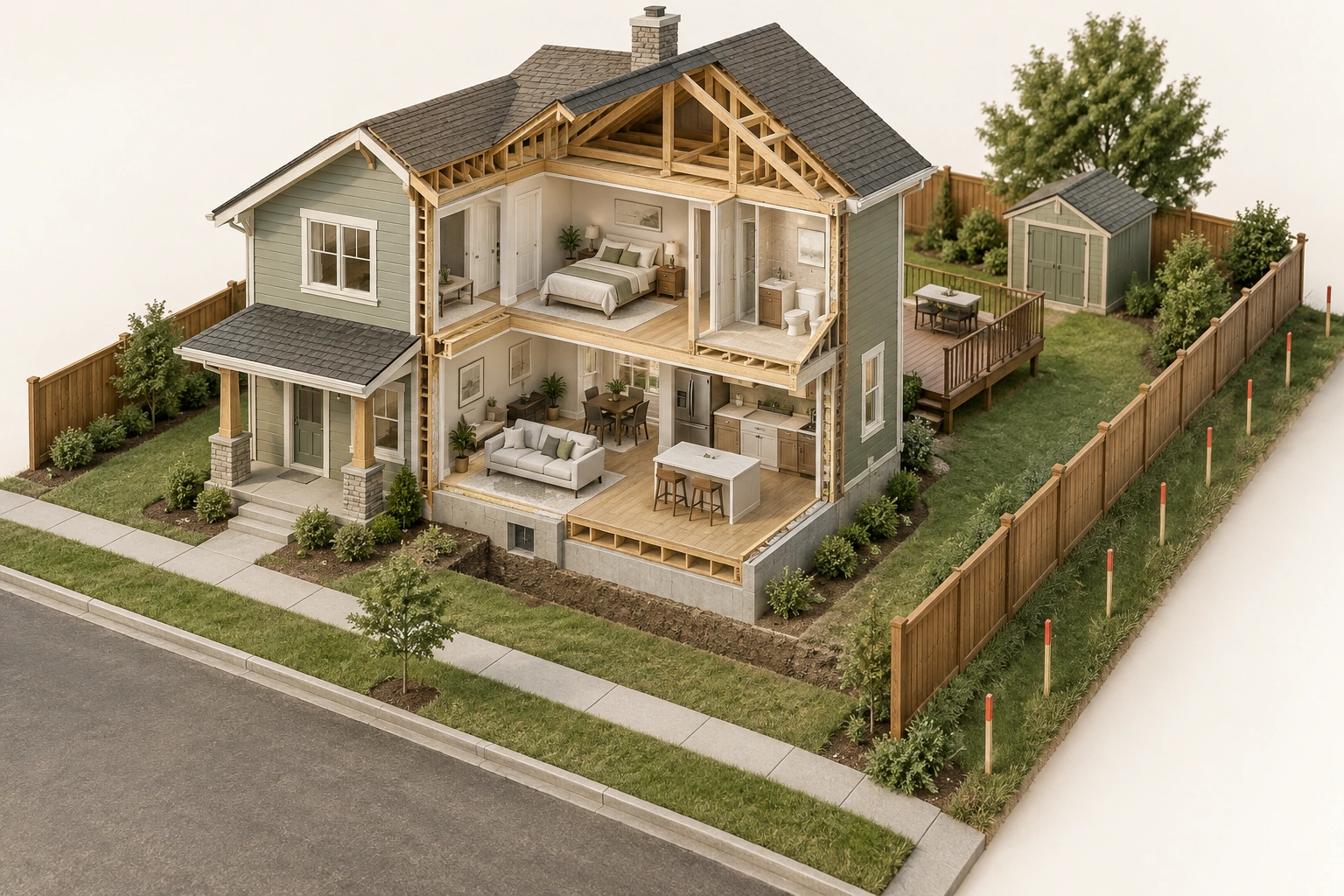
- Fence and stakes
The separate depicted positions explain the occupation/boundary distinction.
- Deck and shed
Later site changes must be reconciled with the actual report.
- Whole parcel context
The viewing includes features whose property identity still needs records.
What does this illustration leave out?
The stakes are fictional teaching markers, not actual survey evidence. No boundary, encroachment, dimensions, permit result or ownership is established. This illustration explains an idea. It is not an installation guide.
Why can a fence and the parcel boundary be different?
Explore this with HomeAI ↗Opens an editable question. Nothing is sent until you choose to send it.One property, different questions
- TitleRegistered ownership and interests.
- SurveyMeasured boundary/site relationships within its scope.
- Municipal reviewThe authority’s expressly stated review.
- InspectionObserved condition within the agreed access and scope.
No record certifies every other question.
Further reading: Alberta — Find land titles, documents or plans; City of Calgary — Certificate of Compliance.
The fence and survey question occupy different places
The fence encloses occupied yard space, while the separate stakes make the boundary enquiry visible. The house, deck and shed are additional features to reconcile with a current professional report. Their different positions explain why a fence, an older survey and the present site can answer different questions.
- Fence
- Occupied feature. Its position does not decide the legal boundary.
- Separate stakes
- Survey enquiry. Fictional markers locate a different question from the fence.
- House, deck and shed
- Current site features. Match these features to the dated professional report.
What remains unknown: The stakes are fictional teaching markers, not actual survey evidence. No boundary, encroachment, dimensions, permit result or ownership is established.
A useful question: Why can a fence and the parcel boundary be different?
No generated text appears in this picture. Separate fictional context, not an installation or property-specific result.
What does a current title identify?
Alberta’s current land-title information explains that a title identifies the owner and registered interests such as mortgages, caveats, easements and builders’ liens. Those labels point to further enquiries. They are not a complete explanation of an instrument’s effect. Ask the legal professional which entries need their underlying registered documents and how they affect the intended purchase and use.
Keep the title search date visible. A search is a record from a particular time, while the transaction may complete later. Ask who will perform the required transaction searches and when. Do not mark an entry resolved solely because someone expects it to be removed. The completion requirements and the evidence of how they were satisfied belong with the legal file.
Alberta provides title searches using identifiers including the legal description, LINC number or title number. The street address is useful for finding the home but should be reconciled with these property identifiers. A search of a similarly numbered parcel can produce an authentic document that answers the wrong question. If there are several titles or units, ask which ones the agreement includes.
A historical title answers a different question: earlier ownership. It may help trace a record enquiry, but it does not replace the current title. The Alberta source separately describes document copies and registered plans. Preserve each document’s identity and purpose. A bundle of official-looking records becomes useful when the reviewer can say which present question each one answers.
If a title entry is unfamiliar, ask what document and advice are needed to understand it rather than requesting a casual translation of the label. The answer may depend on the instrument, plan and transaction context. Keep a copy of the document actually reviewed. A summary without its registration number and date can be difficult to reconcile when a later search displays similar entries.
Match the parcel across the records
The chain matches the intended property to registered identity, its depicted site and observed features. A shared street address alone is not the complete reconciliation.
Numbers identify the parts explained below.
- Purchase agreement
Included property. Identify each title/unit/space represented.
- Current title
Formal identity. Reconcile legal description and identifiers.
- Plan or survey
Depicted site. Confirm the same parcel and report date.
What does this illustration leave out?
No ownership, boundary or included-space finding for an actual property. This illustration explains an idea. It is not an installation guide.
Do all documents concern the same parcel and current features?
Explore this with HomeAI ↗Opens an editable question. Nothing is sent until you choose to send it.Read the complete figure
Match the parcel across the records
An authentic document can still concern the wrong parcel
- Purchase agreement
- Included property. Identify each title/unit/space represented.
- Current title
- Formal identity. Reconcile legal description and identifiers.
- Plan or survey
- Depicted site. Confirm the same parcel and report date.
- Physical viewing
- Observed features. Connect the actual feature to the record.
- Purchase agreement → Current title: Match identifiers.
- Current title → Plan or survey: Match parcel.
- Plan or survey → Physical viewing: Check currency.
The chain matches the intended property to registered identity, its depicted site and observed features. A shared street address alone is not the complete reconciliation.
What remains unknown: No ownership, boundary or included-space finding for an actual property.
A useful question: Do all documents concern the same parcel and current features?
Conceptual teaching diagram. Complete labels and their meanings follow in static text.
Why request the document behind a registered entry?
A short title entry may identify a registration number and a broad type of interest. The underlying instrument may be needed to understand the affected land, parties, conditions and described rights. Ask the legal professional to obtain and interpret the relevant instrument and any referenced plan. Do not infer the width or permitted use of an access strip from the word easement alone.
For a shared-looking driveway, separate three facts: where vehicles actually travel, which parcel contains that surface and what documents authorize the intended use. The physical route could differ from a plan or agreement. The legal professional and surveyor can identify what additional work is needed to reconcile that difference. Watching a neighbour drive through establishes a use observation, not a legal right for the buyer.
The same discipline applies to service routes, drainage areas and other registered interests. Ask what proposed changes would need further advice before you plan a garage, fence or landscaping work. A vacant strip is not necessarily available for building because it looks unused. The actual instrument and applicable municipal requirements must be considered together.
Keep legal interpretation distinct from a location finding. A surveyor can explain the measured features and survey work within the commission. A legal professional interprets the documents and transaction consequences. If one report assumes the answer from the other discipline, identify that dependency rather than treating the assumption as a completed assessment.
Ask specifically whether the advice addresses your intended activity. The right to pass over an area, the ability to park on it and responsibility for its maintenance are distinct questions to put to the reviewer. This guide does not state what any instrument permits. It explains why a buyer who wants to store a trailer should describe that use rather than asking only whether an easement exists.
Follow the driveway before deciding the right to use it
The driveway physically connects the front gate with the rear garages. That complete visible route makes garage access a practical purchase question, while the fences and neighbouring houses locate the parcels to reconcile. A route that looks shared still needs the actual title instrument, plan and legal advice about intended use.
Numbers identify the parts explained below.
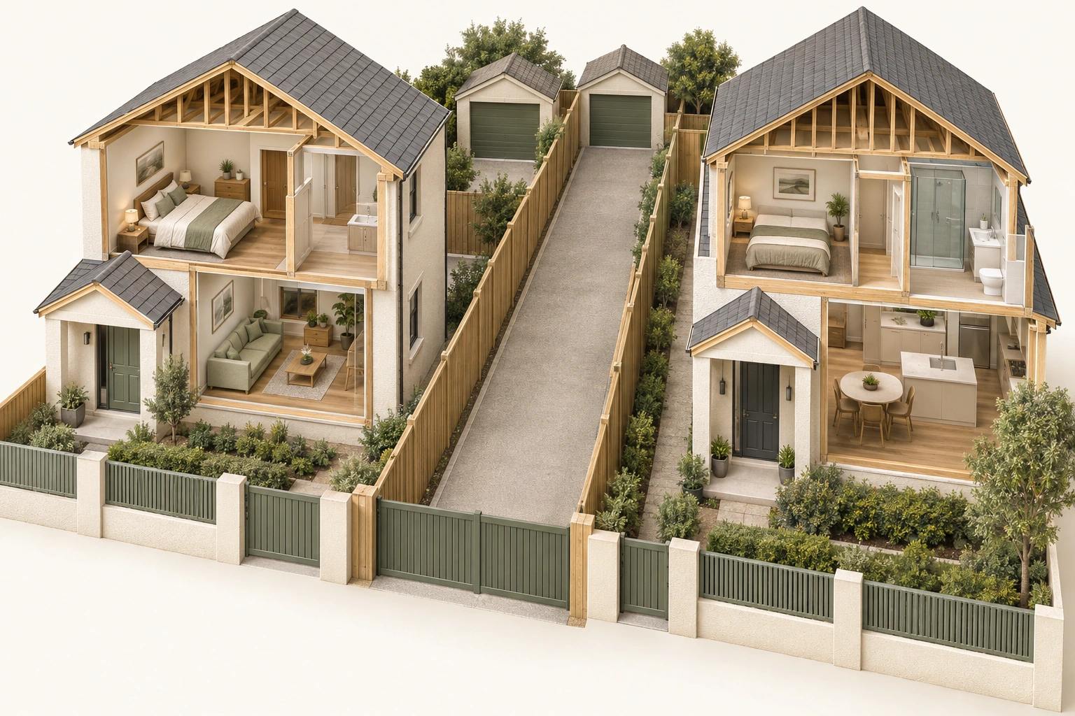
- Driveway to garages
Follow the full visible route rather than judging one front opening.
- Closed gate
Ask how actual access works under the documents and physical arrangement.
- Two houses
Neighbouring use does not itself establish a buyer’s right.
What does this illustration leave out?
No legal boundary, easement, ownership, gate-operating right or right to park is established. The two houses are a separate fictional context from the other site picture. This illustration explains an idea. It is not an installation guide.
How can a physical driveway and an access-right enquiry overlap?
Explore this with HomeAI ↗Opens an editable question. Nothing is sent until you choose to send it.Follow the driveway before deciding the right to use it
The driveway physically connects the front gate with the rear garages. That complete visible route makes garage access a practical purchase question, while the fences and neighbouring houses locate the parcels to reconcile. A route that looks shared still needs the actual title instrument, plan and legal advice about intended use.
- Central driveway
- Travel route. The pictured surface continues to the rear garages.
- Gate and fences
- Access context. Physical barriers do not explain legal rights.
- Neighbouring houses
- Parcel enquiry. Reconcile actual parcels and registered documents.
What remains unknown: No legal boundary, easement, ownership, gate-operating right or right to park is established. The two houses are a separate fictional context from the other site picture.
A useful question: How can a physical driveway and an access-right enquiry overlap?
No generated text appears in this picture. Separate fictional context, not an installation or property-specific result.
How does a survey connect the boundary to visible features?
A Real Property Report in the Calgary process is prepared by an Alberta land surveyor and depicts the site and structures. The City asks for a current report reflecting the property’s actual state. Its page names structures such as the house, deck, shed, fences, retaining walls, window wells and air-conditioning units. A report showing only the original house may leave later changes outside the picture.
Look at the survey date and the features shown before drawing conclusions from a distance printed on the page. Ask whether the visible deck, addition or other feature existed when the work was performed and whether an update is required. A later renovation invoice can help identify a change date but cannot update the survey itself. Calgary states that an Alberta land surveyor must make the update.
An observer can compare obvious depicted features with the site from an authorized viewing position. You can note that a deck is absent from the report or that the drawing labels the property differently. You cannot establish a legal boundary by measuring from a fence with a tape or following a consumer mapping application. Ask the surveyor about the actual survey work needed.
Do not move stakes, expose buried markers or enter neighbouring land to settle the question. Preserve the uncertainty and request professional advice. A useful enquiry describes the discrepancy precisely: the report date, feature concerned, actual viewing date and intended use. That gives the reviewer a focused problem without presenting an amateur boundary conclusion as a fact.
A dated site photograph can help communicate what appears to have changed, provided it is taken from an authorized location and does not expose other people’s private information. Label it as an observation, not survey evidence. Match the feature to the report in your request. The surveyor then decides whether the available material is sufficient or new fieldwork is necessary for the commissioned purpose.
A fence is a feature, not a boundary verdict
The plan deliberately draws a fence inside a separate dashed boundary and shows the house, deck and driveway. Their different locations explain why appearance cannot settle boundary or access rights.
Numbers identify the parts explained below.
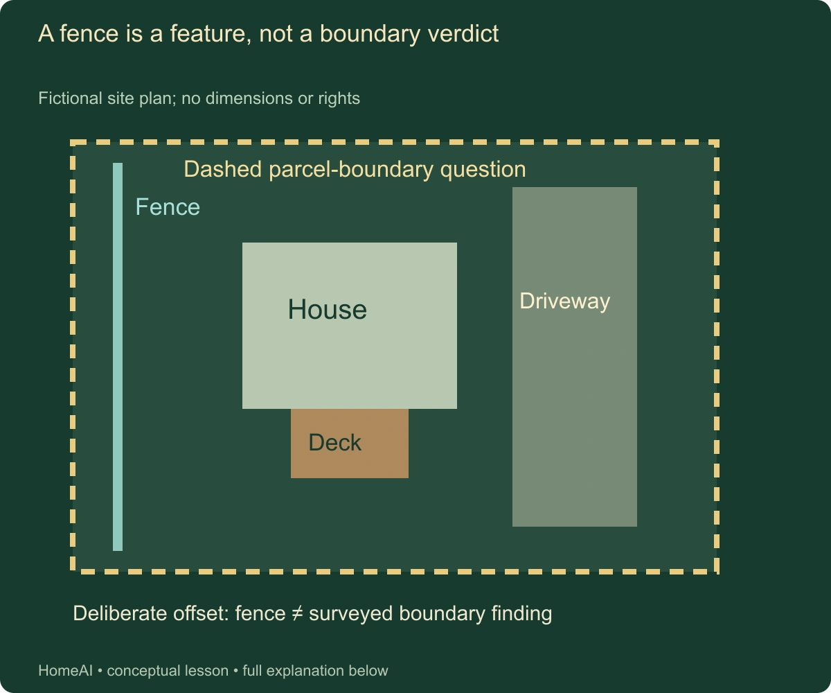
- Parcel boundary
Survey enquiry. Dashed line depicts a conceptual legal-boundary question.
- Fence inside line
Occupation feature. Solid fence is deliberately offset in the illustration.
- House and deck
Current site features. Compare with the dated professional report.
What does this illustration leave out?
The fictional line has no survey authority, dimensions, encroachment verdict or access approval. This illustration explains an idea. It is not an installation guide.
What survey and legal review reconcile the actual feature and intended use?
Explore this with HomeAI ↗Opens an editable question. Nothing is sent until you choose to send it.Read the complete figure
A fence is a feature, not a boundary verdict
Fictional site plan; no dimensions or rights
- Parcel boundary
- Survey enquiry. Dashed line depicts a conceptual legal-boundary question.
- Fence inside line
- Occupation feature. Solid fence is deliberately offset in the illustration.
- House and deck
- Current site features. Compare with the dated professional report.
- Driveway route
- Use and rights enquiry. Physical travel and legal rights need separate review.
The plan deliberately draws a fence inside a separate dashed boundary and shows the house, deck and driveway. Their different locations explain why appearance cannot settle boundary or access rights.
What remains unknown: The fictional line has no survey authority, dimensions, encroachment verdict or access approval.
A useful question: What survey and legal review reconcile the actual feature and intended use?
Conceptual teaching diagram. Complete labels and their meanings follow in static text.
What does Calgary compliance confirm, and what is outside it?
Calgary describes its Certificate of Compliance as confirmation that structure locations comply with the Land Use Bylaw on the submitted Real Property Report. The City expressly separates that service from building-code requirements and permit-history confirmation. Keep those separate questions visible when a seller provides a report stamped for compliance. The stamp is not a whole-house safety or renovation approval.
The City also says it does not review private encroachments as part of this process. It may identify an encroachment into City land or a City right-of-way, but that does not settle every relationship with a neighbour. Ask the legal professional and surveyor about the actual private boundary issue rather than reading a municipal outcome as a universal clearance.
Calgary lists items outside its location-compliance review, including matters that cannot be established from a site plan alone. A fence, retaining wall or building height has questions beyond the plotted structure location. Do not turn an omitted review into a finding that the feature complies or fails. Obtain the separate scope needed for the concern.
The City explains that a compliance certificate may be a private transaction condition and is not universally legislatively required by the City. Your purchase agreement and lender requirements still matter. Ask the legal professional what the actual agreement calls for, what has been delivered and what remains unresolved. Avoid treating a common transaction practice as the same requirement in every Canadian sale.
Read the actual municipal response, including annotations and conditions. An application receipt shows submission; it is not the outcome. A response requesting additional material is still an open review. A certificate attached to a particular report should remain attached to that complete report, so its scope is not detached from the drawing and date on which the review depended.
One municipal review has a defined scope
The location review sits beside three distinct questions. The arrows identify work the certificate does not complete, rather than extending its stamp to the whole property.
Numbers identify the parts explained below.
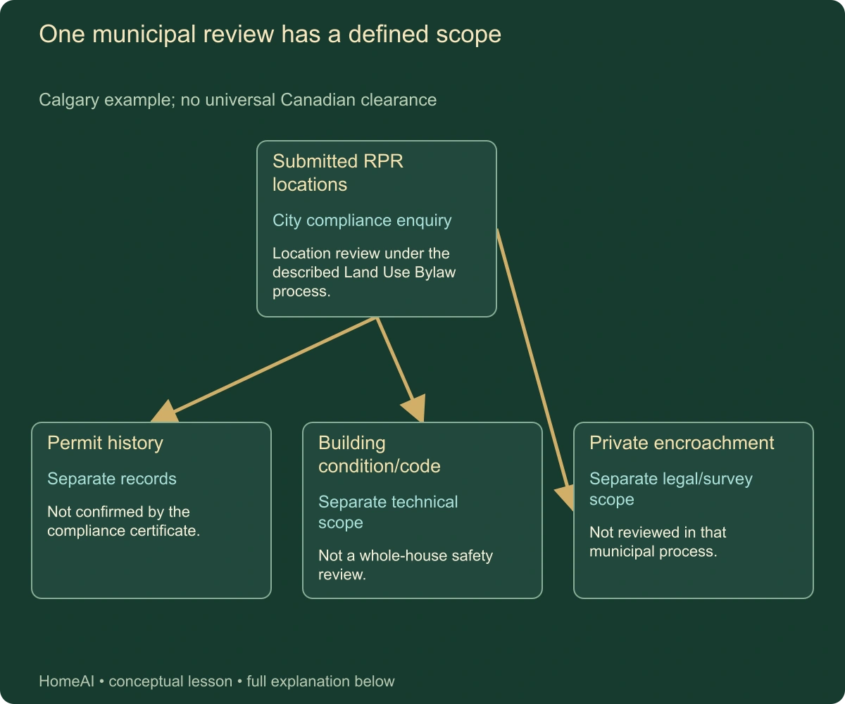
- Submitted RPR locations
City compliance enquiry. Location review under the described Land Use Bylaw process.
- Permit history
Separate records. Not confirmed by the compliance certificate.
- Building condition/code
Separate technical scope. Not a whole-house safety review.
What does this illustration leave out?
No actual municipal result, permitted work, private right or condition determination. This illustration explains an idea. It is not an installation guide.
Which separate scope answers the outstanding concern?
Explore this with HomeAI ↗Opens an editable question. Nothing is sent until you choose to send it.Read the complete figure
One municipal review has a defined scope
Calgary example; no universal Canadian clearance
- Submitted RPR locations
- City compliance enquiry. Location review under the described Land Use Bylaw process.
- Permit history
- Separate records. Not confirmed by the compliance certificate.
- Building condition/code
- Separate technical scope. Not a whole-house safety review.
- Private encroachment
- Separate legal/survey scope. Not reviewed in that municipal process.
- Submitted RPR locations → Permit history: Separate question.
- Submitted RPR locations → Building condition/code: Separate question.
- Submitted RPR locations → Private encroachment: Separate question.
The location review sits beside three distinct questions. The arrows identify work the certificate does not complete, rather than extending its stamp to the whole property.
What remains unknown: No actual municipal result, permitted work, private right or condition determination.
A useful question: Which separate scope answers the outstanding concern?
Conceptual teaching diagram. Complete labels and their meanings follow in static text.
How do permits and an inspection fit beside the survey?
A permit record concerns the work described in that permit and its recorded process. A survey concerns site and location information within its scope. A building inspection concerns observed conditions within the inspection agreement. A successful answer in one channel does not complete the others. A correctly located deck could still have an unresolved construction or permit-history question.
Calgary’s compliance page directs readers to permit-history enquiries and distinguishes the available online history from older records requiring a separate request. Ask for the relevant work rather than assuming the online view is a complete lifetime file. Keep the date range and record-search limits with the result. An empty search within a limited window is not proof that no work occurred.
A non-invasive home inspection can identify useful visible concerns but cannot ensure concealed work has no issues. Before hiring, ask what areas and components the inspection includes, what access is needed, what limitations will be recorded and which findings require another specialist. Do not ask the inspector to certify title, boundaries or legal access unless a separate qualified scope is actually provided.
If a concern crosses disciplines, describe both sides. For example, an addition absent from an older survey may need a survey update, relevant permit records and condition assessment. Do not resolve the whole concern with a single photograph or a contractor’s reassurance. Ask who is responsible for each answer and whether the transaction timetable allows the work to be completed.
An invoice describing a repair does not establish the exact permit or inspection status. Conversely, a recorded inspection stage should be read for the work and date it covers, not expanded into a warranty of every concealed component. Ask the municipality or technical professional about a specific uncertainty. Keep incomplete, unavailable and not-required determinations as different outcomes rather than treating them all as missing paperwork.
Which discrepancies change the next decision?
First identify whether the documents describe the same property and current features. A wrong legal description or missing title is an identity problem. A missing later structure is a currency problem. A registered right that has not been read is an interpretation problem. A damaged structure is a condition problem. Naming the problem helps commission the correct work without pretending to rank its legal seriousness.
Consider a gate across a shared-looking route. The visible gate may affect present access, while the instrument may describe a right with conditions. The survey may locate the gate and route, but the legal advice determines the transaction enquiry. Ask how the intended garage access would work under the actual documents and physical arrangement, including any unresolved discrepancy.
An apparent encroachment is also a question until professionally assessed. Different possibilities can require different responses: the fence may be inside the parcel, a feature may cross the line, the survey may be stale, or the document may concern another part of the site. Avoid starting with a demand that a neighbour move something before the basic evidence is reconciled.
Keep proposed solutions provisional. A revised survey, an agreement, municipal review, work to a structure or another transaction arrangement may be discussed by the appropriate professionals. This article promises none of them. Ask what has actually been accepted by the relevant parties and authorities, what it covers and what evidence will demonstrate completion.
Record who supplied a proposed solution and whether that person has authority to make the relevant decision. A seller’s offer to pay for an update is different from the surveyor completing it. A contractor’s estimate is different from municipal acceptance. Legal advice about an agreement is different from the other party signing it. Those distinctions prevent a promising plan from being mistaken for a completed resolution.
How should the buyer coordinate the review?
Give the legal professional the agreement, current title material, survey or report, municipal outcome, related instruments and the intended use that makes the question important. Tell the surveyor which actual features or discrepancies need attention. Give the building inspector the condition concern and ask what can be assessed safely within the agreed access. A shared question is more useful than asking each person to approve the property generally.
Ask for written scope before relying on a result. Does the survey work update the site features or answer a particular boundary question? Does the municipal response concern the submitted structure locations or another application? Does legal advice cover the actual registered access instrument and purchase condition? Does the inspection include the relevant structure and record its concealed limits?
Preserve dependencies in the timetable. Legal interpretation may need an instrument not yet obtained, a municipal application may need an updated survey, and a repair quotation may need access or technical assessment. Ask your advisers whether an unresolved dependency affects the transaction deadline. Do not assume an application or ordered report will be completed and accepted by a chosen date.
At each step, record the finding and its limit in ordinary language. The survey depicts the current deck location; the City reviewed that submitted location; permit completion remains unanswered. This wording is more useful than a single green check beside property documents. It also lets the buyer see when an additional request repeats an answer already obtained.
Set the scope before commissioning duplicate work. If a current report already depicts the relevant feature, ask the surveyor what remains necessary for the specific purpose. If the concern is the instrument’s wording, another condition inspection may not answer it. This can conserve time while preserving the important boundaries: economy comes from a precise question, not from assuming that a cheaper document provides the same evidence.
Coordinate the disciplines around the discrepancy
A precise discrepancy leads to the survey work needed for its location question, any relevant municipal review and parallel permit, condition or legal enquiries. One completed branch does not finish all others.
Numbers identify the parts explained below.
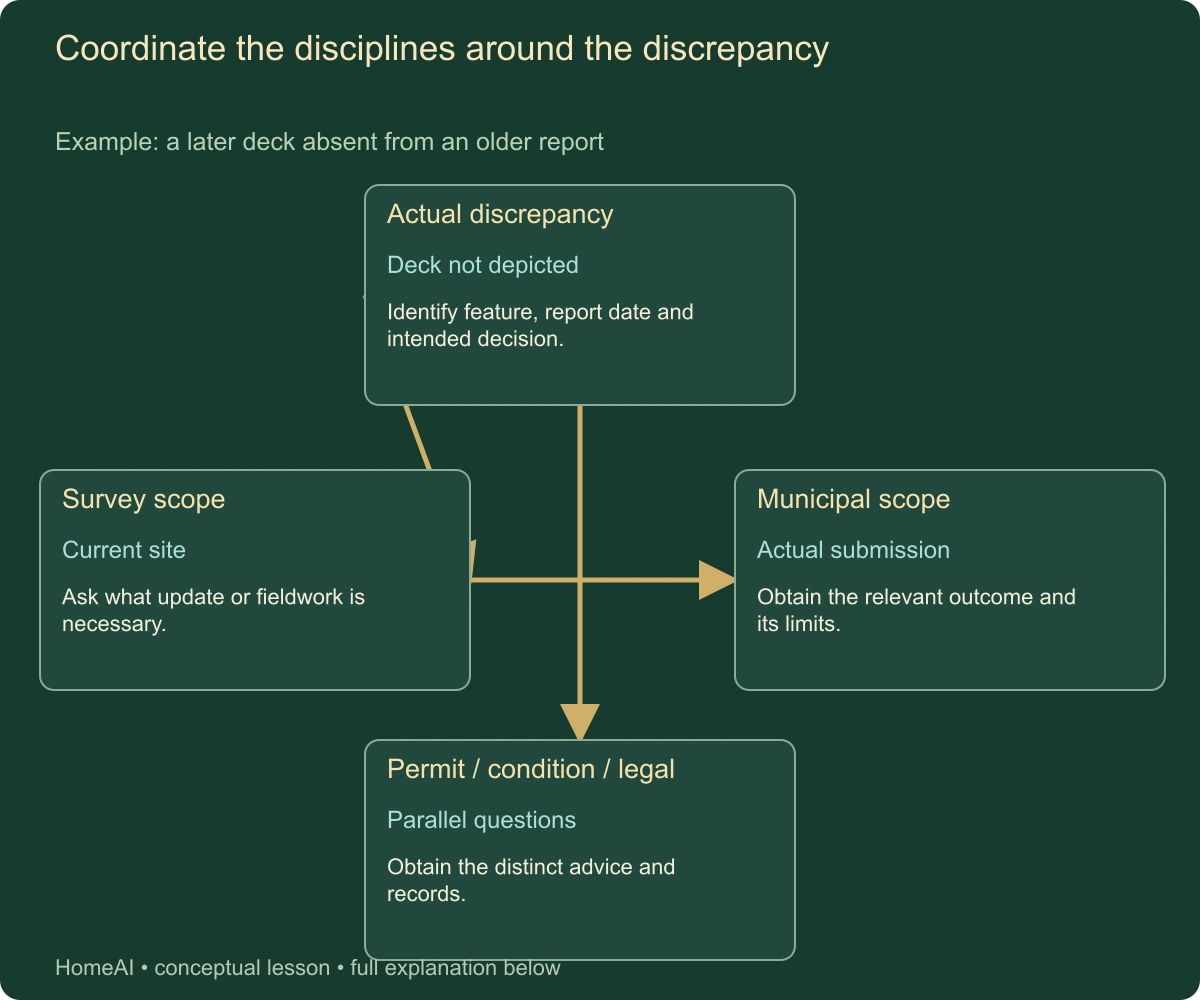
- Actual discrepancy
Deck not depicted. Identify feature, report date and intended decision.
- Survey scope
Current site. Ask what update or fieldwork is necessary.
- Municipal scope
Actual submission. Obtain the relevant outcome and its limits.
What does this illustration leave out?
No mandatory universal sequence, completion date or acceptance. This illustration explains an idea. It is not an installation guide.
Who is responsible for each unanswered part of the actual discrepancy?
Explore this with HomeAI ↗Opens an editable question. Nothing is sent until you choose to send it.Read the complete figure
Coordinate the disciplines around the discrepancy
Example: a later deck absent from an older report
- Actual discrepancy
- Deck not depicted. Identify feature, report date and intended decision.
- Survey scope
- Current site. Ask what update or fieldwork is necessary.
- Municipal scope
- Actual submission. Obtain the relevant outcome and its limits.
- Permit / condition / legal
- Parallel questions. Obtain the distinct advice and records.
- Actual discrepancy → Survey scope: Location question.
- Survey scope → Municipal scope: If required.
- Actual discrepancy → Permit / condition / legal: Other scopes.
A precise discrepancy leads to the survey work needed for its location question, any relevant municipal review and parallel permit, condition or legal enquiries. One completed branch does not finish all others.
What remains unknown: No mandatory universal sequence, completion date or acceptance.
A useful question: Who is responsible for each unanswered part of the actual discrepancy?
Conceptual teaching diagram. Complete labels and their meanings follow in static text.
What does a fictional driveway and deck enquiry look like?
In this fictional Calgary example, Mina considers a house advertised with a rear garage and new deck. The seller provides a Real Property Report dated before the deck was built and a municipal compliance outcome attached to that older report. A current title search lists an access-related registration. These are invented facts for learning, not findings about a real address.
Mina does not conclude that the new deck complies or that garage access is secure. She asks the surveyor what update is needed for the present site, and asks her legal professional to obtain the registered access instrument and reconcile it with the driveway and agreement. She separately requests the deck’s permit and completion records and a condition assessment within the inspector’s scope.
The fictional survey update depicts the deck, but the example deliberately supplies no municipal acceptance, legal access opinion or construction result. Those remain separate outstanding answers. Mina asks her advisers how the unresolved items affect the purchase decision and timetable. The next step follows the actual scope, rather than inventing a clearance because a newer drawing now exists.
If later documents resolve one question, Mina retains their dates and exact scope. If a concern remains, she keeps it visible with the responsible adviser and decision deadline. The lesson is the sequence: identify the parcel, read the interests, reconcile the physical site, obtain the separate reviews and decide using the resulting evidence. It is not a formula guaranteeing a purchase can proceed.
What records should remain after the transaction?
Keep the final relevant title records, instruments and plans with the survey or report, municipal correspondence and transaction advice. Retain permit and inspection evidence separately enough that their different scopes remain clear. Store complete documents rather than cropped stamps or screenshots. A future owner or adviser needs the qualifications, dates and property identifiers as well as the favourable sentence.
When the property changes, note which older record may no longer describe its current physical state. A new deck, changed fence or addition can make a prior drawing incomplete for a later enquiry. Ask the appropriate surveyor or municipality what new work is needed for the actual purpose. Do not edit a signed survey yourself to make its appearance match the yard.
Before planning work near a boundary, registered route or service area, revisit the actual documents with the appropriate advisers. Ownership of a parcel does not by itself answer every restriction, access or approval question. A prior purchase review addressed the transaction and facts then considered; it is not automatic permission for a later project.
The useful handover is a clear account of what was established, by whom, from which documents and on what date. Keep unresolved limitations equally visible. The buyer can then ask a specific next question instead of repeating the entire enquiry or relying on a remembered statement that the title and survey were fine.
Preserve communications that explain a limitation as carefully as favourable outcomes. A record that an area was inaccessible or an instrument unavailable tells the next reviewer why the earlier enquiry stopped. It also helps distinguish a genuinely new question from one that was left open. Update the handover after actual follow-up rather than replacing earlier uncertainty with an undocumented statement that everything was sorted.
Keep learning about the connected parts
- Before you make an offer: what to check, who to ask
- Renovation records: what was proposed, approved and built?
- What changes when the home type changes?
- Cash required for closing: deposit, advance, adjustments and deadlines
- Private roads and shared services: connect access, upkeep and the actual agreement
- Buying a home on leased land: identify the home, site and continuing rights
- Buying beside a lake, river or coast: connect the shore, parcel and whole property
Canadian context and authorities · Visual atlas · Learning labs
Practice the distinction.
A newer survey is one answer, not every answer
Fictional Calgary buyer Mina receives an older report, a later deck and an access-related title entry.
Reported observations
- The deck is absent from the older report.
- The access instrument needs actual legal review.
- Survey update, municipal outcome, permit and condition questions remain separate.
A useful next question
Commission the identified scopes and obtain advice on unresolved transaction conditions; no approval is invented.
Know what the words mean.
- Current title
- A dated registry record identifying the owner and registered interests in the identified parcel.
- Registered instrument
- The underlying document associated with a registered entry; its effect needs legal interpretation.
- Legal description
- The formal property identifier to reconcile across the agreement and records.
- Real Property Report
- An Alberta land surveyor’s site report used in the described Calgary process; its date and scope matter.
- Occupation feature
- A physical feature such as a fence or driveway, distinct from a professionally established legal boundary.
- Compliance review
- The municipal review described by the actual authority, with its stated scope and exclusions.
- Encroachment enquiry
- A question about a feature and a boundary or affected interest, requiring the appropriate assessment.
Questions to bring
to the conversation.
- Do these records identify the same parcel and current features?
- Which underlying instruments and plans were actually reviewed?
- What separate review remains for permits, condition, access or private boundaries?
Separate a showing observation, an existing record and a new professional assessment. Unknown means a question remains; it does not automatically mean a defect.
Use the evidence planner ↗Go to the source.
Original HomeAI explanation informed by these public references. Sources support the underlying guidance; they have not reviewed or endorsed HomeAI. Diagrams are conceptual, and calculator outputs depend on your inputs.
Current Alberta registry and Calgary compliance full bodies read October 13, 2026. Alberta/Calgary examples remain explicitly local. No actual boundary, right, encroachment, permit result, universal contract duty, fee or completion promise is supplied.
Publication & source review
First published .
Sources reviewed .
Have a question about your home?
Start with the symptom, timing and what you have observed.
Ask HomeAI