- Read the wall, retained ground, supporting ground, water routes and surrounding uses as one site question; a face photograph cannot establish the buried arrangement.
- Height and visible material do not decide approval or stability, and nearby construction, drainage or load changes can alter the assessment question.
- Separate intended design, construction field review, completion, later changes and current condition; commission the consequence that matters to the purchase rather than request a generic pass/fail label.
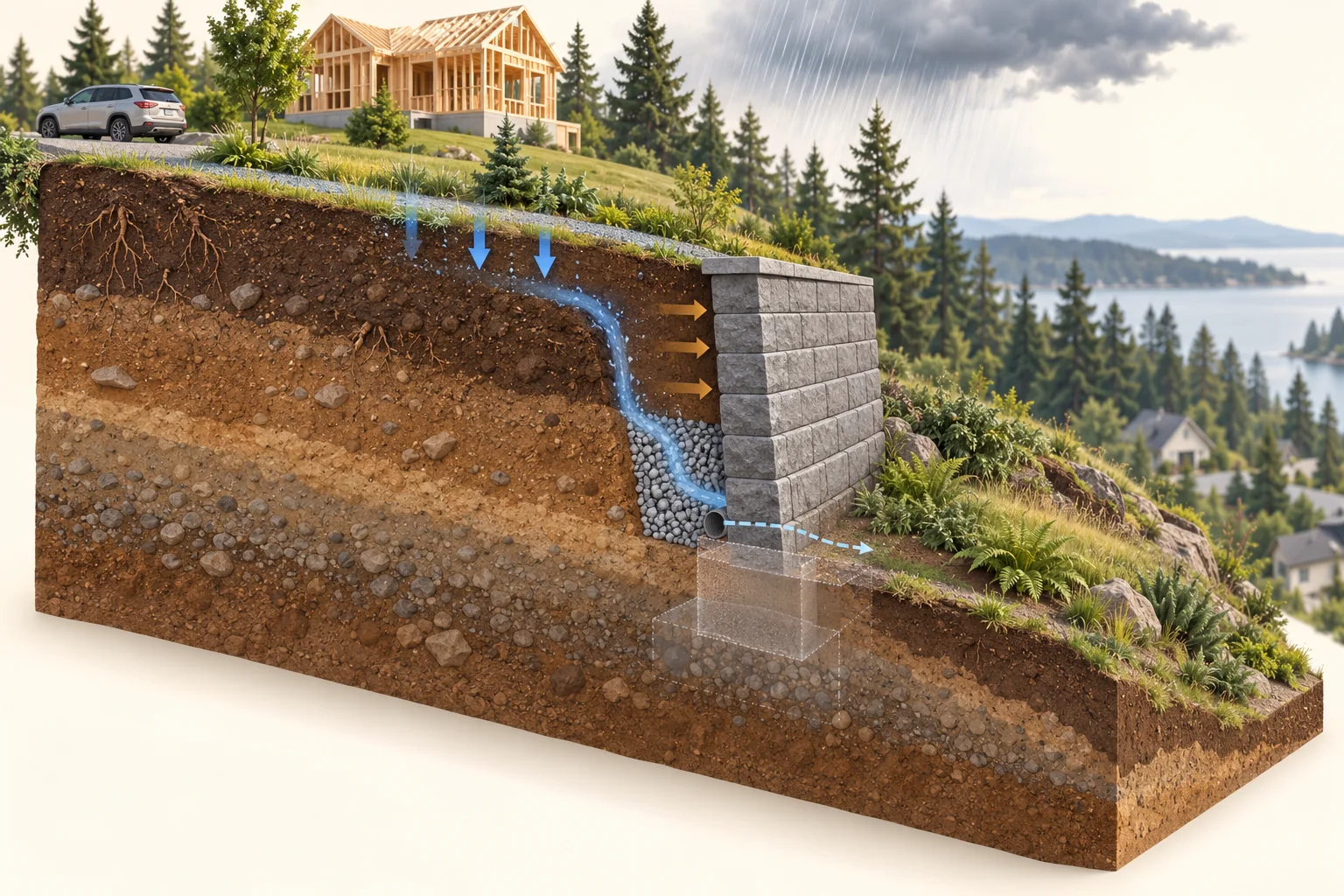
Higher soil sits behind a wall, with a vehicle and house farther upslope. Rain and soil-action arrows, a drainage specimen and a faded support shape sit within the wider terrain.
About this illustration
The specimen proves no soil properties, reinforcement, working drainage, outlet location or authorization, safe setback, capacity or slope stability. The downward route is conceptual and its dashed discharge remains unresolved. No dimensions or construction procedure are supplied. This is a conceptual teaching model, not an assessment of your home.
4 picture lessons appear beside the questions in this guide. Use them to understand the explanation, then consider what it means for your home.
What is this wall retaining, and how does it fit the lot?
A retaining wall helps maintain a difference in ground level by supporting retained material. Start with that relationship: which side is higher, what occupies it, and what lies below or beside the wall? A wall may serve a driveway edge, walkout lot, garden terrace or ground near a building. The consequence of a question can differ greatly even where the visible faces look similar.
Edmonton’s residential grading guidance places retaining walls within elevation differences, walkout and infill drainage arrangements. That local context is useful: the wall is part of the lot, not simply a decorative object beside it. Identify the home, paved areas, neighbouring ground and apparent surface-water routes from ordinary accessible locations, without guessing the property boundary.
Ask whether the wall belongs to a larger subdivision or development design. Nanaimo’s consumer guide expressly excludes some subdivision-plan walls that create building lots, and notes separate development requirements. A recently completed neighbourhood can therefore need the relevant development and wall records, rather than only a small garden-wall checklist. An attractive finished yard does not identify that original scope.
Can similar wall faces conceal different retaining systems?
Concrete, timber, rock or block describes visible material, not the whole supporting arrangement. A gravity wall relies substantially on its weight and associated supporting arrangement. A reinforced concrete cantilever arrangement uses its connected stem and base differently. A reinforced-soil system includes reinforcing elements within the retained ground as well as the face. These are conceptual distinctions, not a way to classify or rate your wall from a photograph.
Permacon’s Grande product page supplies a useful manufacturer example: it lists both gravity and geogrid-reinforced engineering resources for the same product family, with regional product-data variants. The listing does not establish which arrangement was installed at a particular house. It shows why recognising a block or finding a similar online picture answers too little.
Ask for the actual wall identity, design and relevant completed-work evidence. In a reinforced-soil arrangement, part of the system can extend behind the visible face; the extent and condition remain unknown unless established. Do not excavate, pull a block or assume that an unseen component was unnecessary because the face appears straight.
How do soil and water create different actions?
Retained ground acts sideways on the retaining arrangement. Water can introduce pressure as well, while the properties and condition of the ground affect the professional analysis. A water-management question is therefore also part of the support question. Soil visible at the surface does not characterize all the retained fill, founding material or groundwater conditions.
Engineers and Geoscientists BC’s guidance treats lateral ground loading, water and supporting conditions as design inputs. A useful teaching cutaway separates soil action from water action with unscaled arrows. It cannot supply a pressure value or prove which conditions occur behind the actual wall. Record water-related observations with their location and weather context instead of saying that a stain confirms trapped water or that a dry showing confirms drainage.
Bring the question to the appropriate reviewer: which existing site information characterizes the retained and supporting ground, which water assumptions were considered, and what does the present evidence support? Different mechanisms can require different investigation. This lesson gives no earth-pressure calculation, allowable soil value or homeowner test.
Retained soil and water create different questions
Higher soil sits behind a wall, with a vehicle and house farther upslope. Rain and soil-action arrows, a drainage specimen and a faded support shape sit within the wider terrain.
Numbers identify the parts explained below.
- Retained ground
Soil-action arrows identify a concept, with no measured load or material properties.
- Water concept
Water conditions require assessment; the pictured route proves no working drainage.
- Unknown support
A faded buried shape is not an engineered footing or a stability check.
What does this illustration leave out?
The specimen proves no soil properties, reinforcement, working drainage, outlet location or authorization, safe setback, capacity or slope stability. The downward route is conceptual and its dashed discharge remains unresolved. No dimensions or construction procedure are supplied. This illustration explains an idea. It is not an installation guide.
What actual retained ground, water and support evidence should a retaining-wall review include?
Explore this with HomeAI ↗Opens an editable question. Nothing is sent until you choose to send it.Why must drainage lead somewhere rather than simply be present?
Drainage is a route with connected functions: water is collected, carried onward and discharged to an appropriate destination. A visible opening, gravel surface or outlet-shaped pipe does not establish all those links. Concealed collection and conveyance may differ between wall types and sites, so a generic drawing should remain an illustration rather than a map of this property.
Ask what the wall’s drainage records identify, where the actual discharge goes and how the arrangement can be maintained by the responsible party. The BC professional guidance addresses drainage and clogging; a route that cannot perform as intended changes the water-pressure question. Richmond’s bulletin gives a local approval example by distinguishing work connected to its City storm system. Do not infer that such a connection exists, or that the same approval process applies elsewhere.
Consider the next property as well as the wall. Water leaving the wall can still affect lower ground, a building or neighbouring land. Ask how wall drainage fits the documented lot-drainage pattern. Do not insert a hose, clear buried outlets, divert discharge or open the wall to demonstrate flow during a showing.
A drain question extends to the actual discharge
Higher soil sits behind a wall, with a vehicle and house farther upslope. Rain and soil-action arrows, a drainage specimen and a faded support shape sit within the wider terrain.
Numbers identify the parts explained below.
- Collection specimen
An illustrated drainage feature cannot confirm the buried installation.
- Dashed continuation
The real outlet, destination, authorization and ongoing performance remain questions.
- Wider slope
The wall and drainage need the actual terrain context rather than an isolated face photo.
What does this illustration leave out?
The specimen proves no soil properties, reinforcement, working drainage, outlet location or authorization, safe setback, capacity or slope stability. The downward route is conceptual and its dashed discharge remains unresolved. No dimensions or construction procedure are supplied. This illustration explains an idea. It is not an installation guide.
What is known about collection, concealed route and actual permitted discharge at this wall?
Explore this with HomeAI ↗Opens an editable question. Nothing is sent until you choose to send it.Which nearby uses can change the load question?
The retained soil is not the only possible action. A nearby driveway, parked vehicle, structure, stored materials or construction activity may add loading that the reviewer must consider in its actual position and use. Engineers often call additional loading a surcharge. A picture of a lawn cannot answer a future driveway question, and an existing parking habit is not a capacity test.
Describe the relevant uses and their chronology: what was present when the wall was designed, what is present now, and what the buyer intends to change. Include temporary construction access or stored materials if documented. Ask the professional which differences are consequential to the particular system instead of selecting a safe distance from a generic diagram.
Nanaimo’s guide specifically distinguishes walls affecting building-foundation stability from simpler contexts. Toronto’s permit examples also show that location and public access can matter to a local approval enquiry. These examples explain why an assessment brief should include the surroundings. They do not establish a national clearance from a house, driveway or property line.
Nearby uses belong in the load question
Higher soil sits behind a wall, with a vehicle and house farther upslope. Rain and soil-action arrows, a drainage specimen and a faded support shape sit within the wider terrain.
Numbers identify the parts explained below.
- Vehicle landmark
Its drawn distance is not a safe setback or a quantified surcharge.
- Upslope house
Identify actual structures and proposed changes for qualified project review.
- Retaining face
The face alone cannot show reinforcement, support or overall capacity.
What does this illustration leave out?
The specimen proves no soil properties, reinforcement, working drainage, outlet location or authorization, safe setback, capacity or slope stability. The downward route is conceptual and its dashed discharge remains unresolved. No dimensions or construction procedure are supplied. This illustration explains an idea. It is not an installation guide.
Which nearby structures, uses or proposed changes should the retaining-wall reviewer consider?
Explore this with HomeAI ↗Opens an editable question. Nothing is sent until you choose to send it.Could terraced walls and the wider slope interact?
Two short walls with a terrace between them can share a ground question. The upper wall, its retained ground and the use above may affect the lower arrangement; the spacing and actual conditions belong to the professional analysis. Separate-looking faces do not prove that each wall acts independently. Record all the relevant levels and features in the site overview.
A wall can also be one part of a larger hillside. Local wall behaviour and broader slope behaviour are different scopes: a review of the face or base alone need not address movement through surrounding ground. The BC professional guidance includes global stability, meaning the wider ground-and-wall system rather than just an individual component.
Ask whether the existing report included interacting walls, ground above and below, and relevant building or access consequences. A report for one terrace or an adjacent parcel can provide context without answering every part of this lot. Keep the actual investigation locations and limitations visible. No sketch in this guide supplies an influence boundary, slope ratio or stable zone.
Two walls belong to one wider slope context
Two walls sit within one continuous slope. A house and driveway provide upslope context; dashed soil-water concepts and ghosted rectangular support shapes appear near the walls.
Numbers identify the parts explained below.
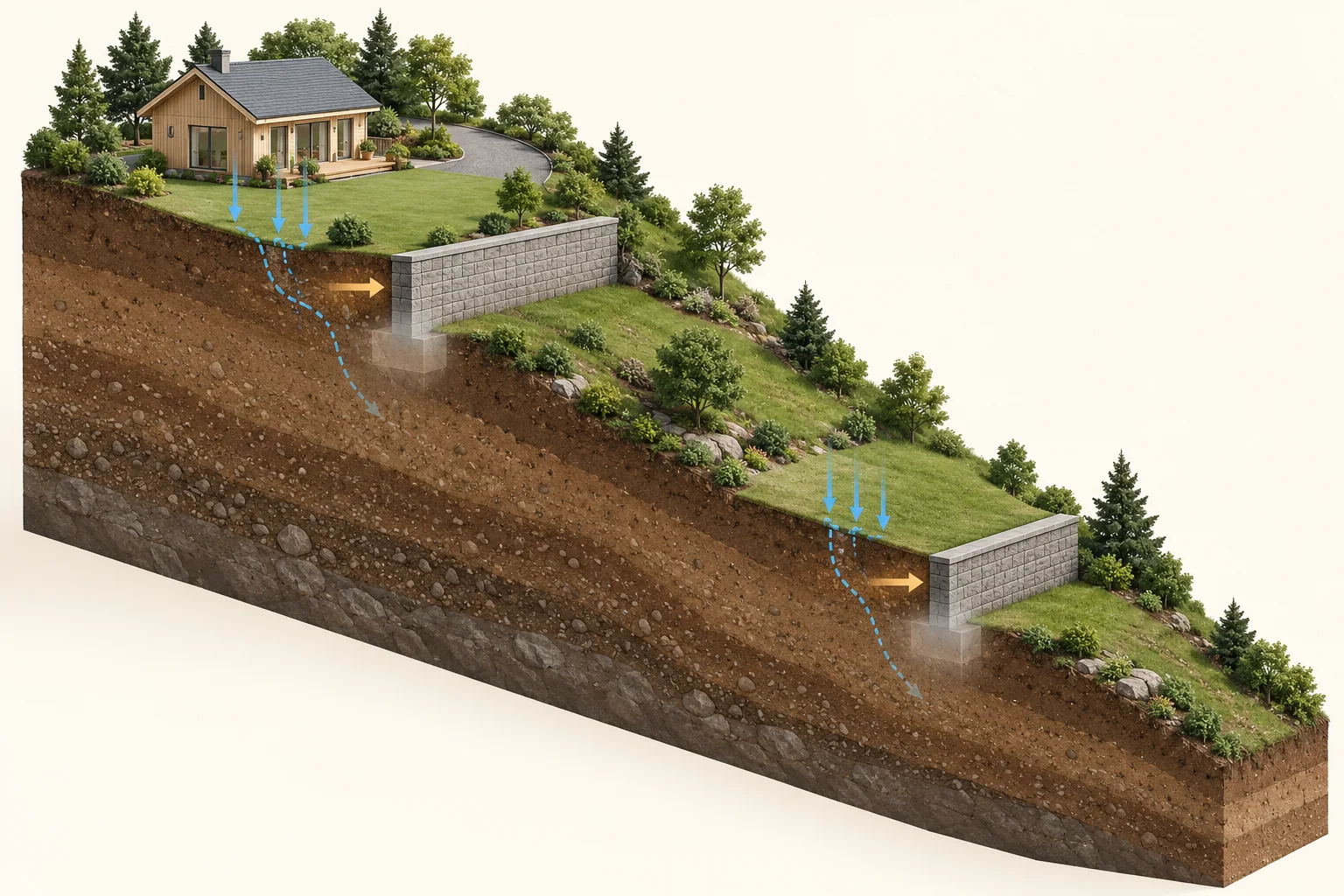
- Upper wall
Identify its actual retained ground, water and support scope.
- Lower wall
Another level may matter; this picture establishes no extent of interaction.
- Continuous hillside
The actual broader slope requires assessment, with soil and supports still unknown.
What does this illustration leave out?
No wall design, support geometry, actual subsurface path, approved discharge, stable ground, safe distance or extent of wall interaction is established. A professional must evaluate the real slope and project; illustrated spacing is not a setback rule. This illustration explains an idea. It is not an installation guide.
Could terraced walls or the wider slope matter to this purchase or planned change?
Explore this with HomeAI ↗Opens an editable question. Nothing is sent until you choose to send it.What can a buyer record safely during an ordinary visit?
Use permitted ordinary access to make a location-based overview: the wall, higher and lower ground, nearby uses, visible outlets and concealed or inaccessible portions. Note the date, weather, season and reported recent work. Describe visible changes such as separated-looking joints, displaced-looking units, leaning-looking portions, erosion or water marks without assigning a cause from their appearance alone.
Comparable earlier photographs and repair records can be more informative than a single close-up. Ask which location they show and whether landscaping or grade changed between them. Snow, vegetation, fencing and stored items should remain recorded access limits. A fresh finish can conceal history without proving that the seller hid a problem; ask for the work scope and prior findings.
Do not stand at an exposed edge or below a questionable wall, climb it, push it, load it or excavate beside it. If material is falling or there is apparent immediate movement or instability, keep people clear and arrange appropriate urgent help. The aim is a useful observation record, not an informal stability demonstration.
Does height, material or a permit settle the buying question?
Height is one input into local requirements, not a stability verdict. A wall’s role near a foundation, its location, surrounding use and particular ground conditions can also matter. Different authorities use different scopes and measurement contexts. This guide deliberately gives no Canadian-wide permit height, exemption, allowable slope or mandatory clearance.
Calgary, Toronto and Nanaimo provide named local examples, and each must be read within its jurisdiction. Toronto’s examples are non-exhaustive. Nanaimo identifies particular site and foundation consequences and excludes some subdivision-plan walls. Ask the actual authority which planning/building and development records apply at the address and to the work in question.
A permit entry is valuable evidence of an approval process; it does not alone establish the current condition or every concealed construction detail. Likewise, the absence of a record in a supplied packet does not prove that no approval exists or that one was required. Establish what was searched and which stage was covered before deciding what further enquiry matters.
How do design, field review and completion records fit together?
A design describes the intended arrangement and assumptions. Construction field review addresses implementation and actual site conditions within its scope. Completion and assurance records provide another link, while later repairs and use changes add a new chronology. Keep these roles separate instead of treating a stamped drawing as evidence that all the work was built as drawn and remains unchanged.
Nanaimo’s local guide explains field review in relation to the engineering intent and the actual conditions encountered. The current BC professional guideline distinguishes a design/commitment assurance statement from the statement following field review. Those named BC forms are examples of different evidence stages, not a national requirement to request a particular form number.
Match each available document to the wall location, date, author, revisions, inspected components and unresolved conditions. Ask how changes found during construction were recorded and whether the final packet refers to the revised arrangement. A maintenance invoice or surface repair can establish useful narrower work without renewing the original design or verifying every buried element.
What should a scoped investigation answer for this purchase?
Tell the reviewer the decision and consequence: a reported change, uncertain drainage, proximity to a building, missing construction evidence or a proposed new use. Ask who will address structural components, retained and supporting ground, water and the wider site, and how those responsibilities fit together. Relevant engineering/geotechnical expertise may be needed beyond a general home-inspection observation.
The initial assignment can reconcile existing information before deciding whether investigation, monitoring or further access is appropriate. Ask what the written conclusion will cover, which methods are authorised, where the assessment can and cannot establish conditions, and what reliance or next steps it supports. Buried drainage, reinforcement and support should remain unknown where the work did not establish them.
Keep property rights and access separate from the physical finding. Richmond’s bulletin raises survey/non-encroachment questions; Calgary’s preparation guidance addresses title restrictions. Have the appropriate advisers explain the actual boundaries, agreements and access or maintenance responsibilities. The wall’s appearance, height or place beside a fence does not identify ownership or decide who pays.
What if I want to change the lot after purchase?
A wider driveway, added building, excavated lower yard or redirected water route can change the conditions around an existing wall. Include the proposed work in the professional brief before relying on the old assessment. The BC guideline identifies changed loads, fill removal, drainage changes and construction above or below as matters for review.
For a new-build handover, compare the completed site with the relevant accepted plans and construction-review findings, including landscaping or access work added later. Edmonton’s grading context is a reminder that the wall and the surrounding drainage pattern belong together. Approval of an earlier stage should not silently cover a subsequently changed grade or use.
A seller can preserve the original and changed-work records in sequence; a buyer can ask which consequence must be resolved before relying on an intended use. Do not ask a landscaper to trial a grade or load change to see whether the wall responds. An agreed professional scope and applicable local permissions should establish the suitable next step.
How would a fictional buyer read a neat wall and mixed records?
Explicitly fictional home: a seller supplies an old wall drawing and a recent invoice for new paving above it. Photographs show a small water mark, but the buried drainage route is not identified. There is a second lower terrace, and the buyer wants to use the upper area for vehicle parking. These invented facts do not establish failure, blocked drainage, unapproved work or misrepresentation.
The buyer maps both walls and the surrounding uses, then asks a qualified reviewer whether the drawing, later paving and proposed parking describe the same assessed conditions. A drainage enquiry identifies what route and discharge evidence is available. The authority and legal adviser separately address the relevant approval and property-arrangement questions.
Suppose a report later addresses the visible wall and supplied design but excludes buried reinforcement and the wider slope. Keep those limits alongside its actual findings, rather than rewriting it as a whole-site clearance. The buyer can then judge the consequential remaining question with the advisers. A stronger file supports that decision without inventing a stability score or predicting a future failure.
Keep learning about the connected parts
Practice the distinction.
New paving above an older wall changes the buyer’s question
Explicitly fictional buyer, two terraces and documents. An old drawing, later paving invoice and water mark do not establish the concealed drainage or support arrangement.
Reported observations
- The wall drawing predates the paving invoice.
- The buyer proposes parking on the upper area.
- A lower terrace is visible but no combined-slope scope is supplied.
- A water mark is recorded without a drainage-route finding.
Compare the explanations
Expand each possibility to see the evidence needed to distinguish it. Similar symptoms can have different mechanisms.
The records cover narrower stages than the intended use
The original design and paving work may remain useful while changed loading and interacting-wall questions need reconciliation.
A chronology-matched professional scope addressing the actual original/current/proposed configuration.
Water and broader ground questions remain unassessed
Visible marks and separate-looking walls identify enquiries without proving pressure, a blockage or instability.
Qualified drainage/support/slope findings with actual methods, locations and concealed exclusions.
A useful next question
Map the lot and changes, request the consequential physical review and obtain separate local approval and property-arrangement answers.
No real wall, stability score, hidden defect, design, drainage procedure, clearance, permit status or ownership finding is represented.
Know what the words mean.
- Retained ground
- The soil or other ground material whose level the wall arrangement supports; its actual composition and condition require appropriate evidence.
- Surcharge
- Additional loading considered in the assessment, such as nearby vehicles, structures or stored materials; no safe distance or allowed load follows from the term alone.
- Gravity wall
- A retaining arrangement whose resistance depends substantially on its weight and associated supporting arrangement; a visible block face does not establish this classification.
- Reinforced-soil system
- An arrangement in which reinforcing elements within the soil and the wall face form parts of the retaining system; the concealed extent must be established.
- Hydrostatic pressure
- Pressure from water that can be relevant behind a retaining arrangement; a stain alone does not measure or confirm it.
- Drainage route
- The connected collection, conveyance and discharge arrangement, with the actual destination and maintenance/access questions retained.
- Global stability
- The broader ground-and-wall stability question, distinct from checking an individual wall component or visible face.
- Field review
- Professional review of implemented work and site conditions within its stated scope; distinct from the original design and a later current-condition assessment.
Questions to bring
to the conversation.
- What ground-level difference does the wall serve, and what nearby building, driveway, access route or property relies on that arrangement?
- Which records identify the actual retaining system, supports and concealed elements?
- What surface-water and below-ground drainage route was documented, including its actual discharge and access arrangements?
- Which buildings, vehicle uses, stored loads, fill or later work were considered in the relevant design or assessment?
- Were terraced walls and the wider slope considered together where needed?
- What safe, dated observations and change history can be linked to specific locations?
- Which local planning/building, survey, property-agreement and drainage-connection records actually apply?
- What professional design, field-review, completion and current-assessment findings exist, with which exclusions?
Separate a showing observation, an existing record and a new professional assessment. Unknown means a question remains; it does not automatically mean a defect.
Use the evidence planner ↗Go to the source.
Original HomeAI explanation informed by these public references. Sources support the underlying guidance; they have not reviewed or endorsed HomeAI. Diagrams are conceptual, and calculator outputs depend on your inputs.
Publication & source review
First published .
Sources reviewed .
- Engineers and Geoscientists BC · Retaining wall design
Where this reference applies
Jurisdiction: British Columbia professional engineering practice; qualitative concepts inform education without exporting its regulatory obligations
Edition: Version 1.2, published October 10, 2024; 57 PDF pages. Definitions, scope, owner responsibilities, investigation, loads, drainage, broader stability, field review and assurance sections substantively read.
Source reviewed: 2026-10-03 · UTC
Qualitative soil/water/load/support relationships, interacting walls/slopes, changed conditions and design versus construction-review evidence. Factors of safety, height triggers, influence planes, load values, dimensions, design procedures and excavation sequences are excluded; superseded v1.1 reads remain research history only.
- City of Calgary · Fences and retaining walls
Where this reference applies
Jurisdiction: Calgary, Alberta planning/building and title-restriction context; not an official legal interpretation or national approval rule
Edition: Current web permit/preparation/design/inspection sections read; no publication date established
Source reviewed: 2026-10-03 · UTC
Different local approval questions, property documents and inspection records. No numeric trigger or existing-wall compliance verdict. A linked 2016 checklist gives a conflicting threshold; that unresolved research comparison is retained without publishing either number.
- City of Edmonton · Residential lot grading guidelines
Where this reference applies
Jurisdiction: Edmonton, Alberta small-scale residential lot grading, including walkout and infill situations; excludes the separately addressed larger/commercial classes
Edition: August 2025; 33 PDF pages; introduction and printed page 14 retaining-wall section substantively read
Source reviewed: 2026-10-03 · UTC
How elevation differences, retaining arrangements and the property drainage pattern relate. Local support, drainage and approval questions are retained as local examples; no national height, grade, discharge or material requirement is prescribed.
- City of Nanaimo · Retaining wall guide
Where this reference applies
Jurisdiction: Nanaimo, British Columbia local wall permits; expressly excludes certain subdivision-plan walls and notes separate property-specific development requirements
Edition: Revised January 2025; seven PDF pages; bounded pages 1–4 substantively read
Source reviewed: 2026-10-03 · UTC
Foundation consequences, materials, actual site conditions, professional design/field review and completion evidence. Local numerical triggers, drawings, construction specifications and approval recipes are not adopted; height alone does not resolve the local assessment.
- City of Richmond · Wood retaining walls
Where this reference applies
Jurisdiction: Richmond, British Columbia wood-wall and adjacent-property context; bulletin is subordinate to applicable law
Edition: BUILDING-07; originally July 27, 1998, revised July 2, 2025; substantive page 1 of two-page PDF read
Source reviewed: 2026-10-03 · UTC
Adjacent-property effects, drainage connection approval and survey/non-encroachment questions. No height trigger, prescribed design, membrane detail, installation procedure or inferred City storm connection.
- City of Toronto · When a building permit is needed
Where this reference applies
Jurisdiction: Toronto, Ontario common-project examples; page expressly non-exhaustive and zoning remains separate
Edition: Introduction, retaining-wall example and list caveats substantively read; no issue date established
Source reviewed: 2026-10-03 · UTC
Why local location/public-access context and applicable rules belong in the approval enquiry. No numerical threshold, universal permit exemption or existing-wall approval.
- Permacon · Grande wall technical-resource variants
Where this reference applies
Jurisdiction: Canadian manufacturer’s identified product resources with regional data variants; not evidence of an installed product or a municipal rule
Edition: Web product description and technical/standard-design resource labels substantively read; no document issue date established
Source reviewed: 2026-10-03 · UTC
The same product family has listed gravity and geogrid-reinforced engineering resources, plus region-specific product data. No linked design chart was evaluated or adopted; marketing height/capacity claims, product recommendation and installation instructions are excluded.
Have a question about your home?
Start with the symptom, timing and what you have observed.
Ask HomeAI